MEXICO CITY (AP) — Hurricane Delta rapidly intensified into a Category 2 hurricane early Tuesday, packing 110 mph (175 kmh) winds on a course to hammer southeastern Mexico and then grow to a potentially catastrophic Category 4 as it approaches the US Gulf coast.
As Delta shifted west on Monday, Cuba withdrew a hurricane warning for its western province of Pinar del Rio and replaced it with a tropical storm warning. There was also a tropical storm warning for the Cayman Islands including Little Cayman and Cayman Brac.
The immediate worst impacts of this hurricane were expected along the resort-studded northeastern tip of Mexico’s Yucatan Peninsula, which was forecast to start seeing hurricane conditions Tuesday night and landfall early Wednesday. A hurricane warning was in effect for Tulum and Cozumel, resorts still being soaked Tuesday by the remnants of Tropical Storm Gamma.
“I honestly don’t see much that will stop it until it reaches Yucatan, due to low vertical wind shear, high deep-layer moisture, and the very warm and deep waters of the northwestern Caribbean,” National Hurricane Center forecaster Eric Blake said.
Data from a US Air Force Reserve Hurricane Hunter aircraft indicate that Delta will continue to strengthen as its forward speed increases, the US Hurricane Center said. It’s expected to hit the Yucatan as a major hurricane Wednesday before moving over the Gulf of Mexico on Thursday. Forecasters warned of an extremely dangerous storm surge raising water levels by as much as 6 to 9 feet (2 to 3 meters) in the Yucatan, accompanied by large and dangerous waves, and flash flooding inland.
Delta “presents an important danger for the coastal regions” because of the storm surge in the lower parts of Quintana Roo, such as the resorts of Cancun, Holbox island or Isla Mujeres, Jorge Zavala, head of Mexico’s meteorological service, said in a press conference late Monday.
Zavala said preventative evacuations would begin Tuesday morning.
Delta’s center on Monday was about 370 miles (595 kilometers) east-southeast of Cozumel, Mexico, moving west-northwest at 15 mph (24 kmh).
Once it moves on from Mexico, Delta is expected to become even stronger over the Gulf of Mexico, sustaining winds up to 130 mph (115 kph) as it approaches the US Gulf Coast, where landfall around Friday would be followed by heavy rainfall across the southeastern United States.
“While there is large uncertainty in the track and intensity forecasts, there is a significant risk of dangerous storm surge, wind, and rainfall hazards along the coast from Louisiana to the western Florida Panhandle beginning Thursday night or Friday. Residents in these areas should ensure they have their hurricane plan in place and monitor updates to the forecast of Delta,” the Hurricane Center said.
Delta is the earliest 25th named storm to form in the Atlantic, beating the old record of Nov. 15, 2005, according to Colorado State University hurricane researcher Phil Klotzbach.
___
AP writer Seth Borenstein in Washington contributed to this report.
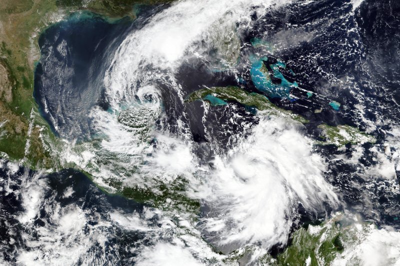
Image: This Monday, Oct. 5, 2020, satellite image released by NASA Worldview, Earth Observing System Data and Information System (EOSDIS) shows Tropical Storm Gamma, left, which soaked part of Mexico over the weekend and a strengthening Hurricane Delta, lower right, which is on a course to pass by the Cayman Islands early Tuesday. (NASA via AP)

