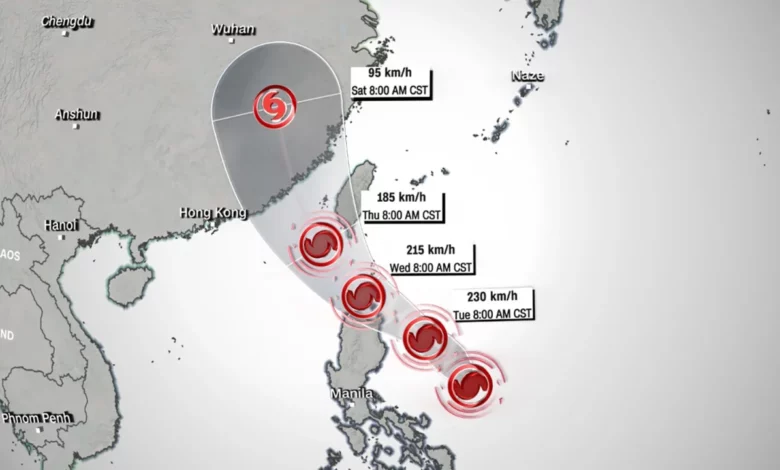
Typhoon Doksuri began as a tropical storm in the Western Pacific on Sunday morning, according to the United States’ Joint Typhoon Warning Center. By the end of the day, it had been upgraded to a typhoon with maximum winds of 230 kilometers per hour (140 miles per hour), according to Philippines weather agency Pagasa.
The typhoon is now approaching Luzon, the Philippines’ largest and most populous island, where it’s expected to hit the island’s northeastern edge Tuesday local time, bringing up to 10 inches of rainfall.
That could increase to about 18 inches of rainfall by Wednesday as the typhoon intensifies and heads toward the northern part of the South China Sea – spelling potential trouble for Taiwan, Hong Kong, and parts of southern China.
Doksuri, also known as Egay in the Philippines, could become a supertyphoon by late Tuesday or early Wednesday, Pagasa warned – the equivalent of a Category 5 hurricane, the highest and most destructive level on the scale.
At that level, storms can cause catastrophic damage to residential areas, depending on wind speeds and the extent of coastal storm surges.
It could then begin weakening late Wednesday as it enters the Taiwan Strait, Pagasa forecast.
But the typhoon’s exact path is still uncertain, with the Hong Kong Observatory saying over the weekend there were several possible routes it could go.
The typhoon could pass over the island of Taiwan; it could swing south, missing Taiwan and hitting the southern coast of China’s Guangdong instead, including Hong Kong; or it could go north, largely sparing both.
The observatory said the typhoon’s final trajectory will be guided by a variety of factors, such as subtropical ridges that bring high atmospheric pressure, or monsoon troughs that bring low pressure.
Communities in the typhoon’s path are now bracing for impact, with Philippine President Ferdinand R. Marcos Jr. suspending all public school classes and closing government offices in the capital region on Monday, except for those performing critical services. The suspension was also in part due to a 3-day strike by transport workers.
Pagasa also urged people living in “highly susceptible” areas to follow evacuation orders and other instructions from local officials.
The Hong Kong Observatory has asked the public to monitor weather announcements, warning the typhoon will bring high heat and thunderstorms ahead of its arrival. The city has just experienced another storm, Typhoon Talim, a week ago, which prompted authorities to close schools and the stock market.
Taiwan’s weather agency said Sunday night it was monitoring the typhoon’s progress, and could issue a warning at sea later Monday or Tuesday. Vessels at sea should be vigilant, and residents should be cautious when going to the beach due to the possibility of large waves, it said.